

Industries
At Drone & Render Co., we believe every industry benefits from a clearer view of the world. What began as a tool for real estate has evolved into a full-service aerial and 3D data platform serving construction, aggregates, agriculture, utilities, municipalities, and more. By combining high-resolution drone imagery with advanced mapping, modeling, and rendering technology, we deliver actionable insights tailored to the unique needs of each sector. Whether it’s measuring stockpiles, monitoring crop health, documenting infrastructure, or creating immersive marketing visuals, our solutions are designed to help businesses plan smarter, operate more efficiently, and showcase their projects with unmatched accuracy and detail.
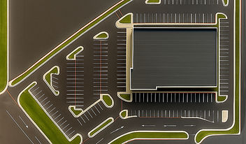
Real Estate & Commercial Marketing
Produce high-quality aerial imagery, videos, 3D tours, and virtual staging.

Aggregates / Quarries
Deliver accurate stockpile measurements, pit planning models, and orthomosaic maps.

AEC / Construction
Capture pre-construction surveys, track progress, and create as-built documentation.

Survey & Mapping
Provide centimeter-level topography, GIS datasets, and detailed site maps.

Land Development
Generate concept plans, massing renders, and entitlement support visuals.

Municipal / Government
Create asset inventories, right-of-way maps, and support public works planning.
...and more
-
Agriculture – Monitor crop health, stand counts, irrigation, and generate prescription maps.
-
Utilities & Energy – Inspect solar farms, substations, and transmission lines with thermal and visual data.
-
Roofers & Building Envelope – Document roof conditions and detect leaks using thermal imagery.
-
Insurance & Claims – Supply post-event documentation and scope verification for claims adjusters.
-
Telecom – Conduct tower inspections and analyze line-of-sight for new installations.
-
Transportation / Infrastructure – Map and inspect roads, bridges, and rail corridors for maintenance and planning.
-
Environmental / Land Management – Track wetlands, erosion, and habitat restoration projects.
-
Industrial Facilities – Provide site mapping, safety visuals, and detailed LiDAR documentation.
-
Hospitality / Tourism – Capture aerial visuals to market resorts, venues, and recreational sites.
-
Events & Sports – Produce promotional aerial footage and assist in site logistics planning.
-
Emergency / Public Safety – Support disaster response and search-and-rescue with real-time mapping.
-
Wind / Solar – Inspect blades and panels for damage or anomalies using high-resolution and thermal data.
-
Water / Wastewater – Survey ponds, lagoons, and treatment plants for condition assessment.
Let’s put your projects on the map—literally. Whether you’re building, measuring, marketing, or planning, we’ll bring the perspective that makes the difference. Reach out and let’s explore what’s possible.


